Showing posts with label US STATES. Show all posts

Friday, 5 October 2018

USA - ILLINOIS / State of Illinois

Illinois  is a state in the Midwestern region of the United States. It is the 6th-most populous U.S. state and 25th-largest state in terms of land area, and is often noted as a microcosm of the entire United States.  With Chicago in the northeast, small industrial cities and great agricultural productivity in northern and central Illinois, and natural resources such as coal, timber, and petroleum in the south, Illinois has a diverse economic base, and is a major transportation hub. The Port of Chicago connects the state to other global ports around the world from the Great Lakes, via the Saint Lawrence Seaway, to the Atlantic Ocean; as well as the Great Lakes to the Mississippi River, via the Illinois Waterway on the Illinois River. The Mississippi River, the Ohio River, and the Wabash River form parts of the boundaries of Illinois. For decades, Chicago's O'Hare International Airport has been ranked as one of the world's busiest airports. Illinois has long had a reputation as a bellwether both in social and cultural terms and politics. Illinois's eastern border with Indiana consists of a north-south line at 87° 31′ 30″ west longitude in Lake Michigan at the north, to the Wabash River in the south above Post Vincennes. The Wabash River continues as the eastern/southeastern border with Indiana until the Wabash enters the Ohio River. This marks the beginning of Illinois's southern border with Kentucky, which runs along the northern shoreline of the Ohio River.  Most of the western border with Missouri and Iowa is the Mississippi River; Kaskaskia is an exclave of Illinois, lying west of the Mississippi and reachable only from Missouri. The state's northern border with Wisconsin is fixed at 42°  30' north latitude. The northeastern border of Illinois lies in Lake Michigan, within which Illinois shares a water boundary with the state of Michigan, as well as Wisconsin and Indiana.
Illinois is located in the Midwest Region of the United States and is one of the eight states and Canadian province of Ontario in the bi-national Great Lakes region of North America.  


Jia

Wednesday, 26 September 2018

USA - SOUTH CAROLINA / State of South Carolina

South Carolina  is a state in the Southeastern United States and the easternmost of the Deep South. It is bordered to the north by North Carolina, to the southeast by the Atlantic Ocean, and to the southwest by Georgia across the Savannah River.
South Carolina became the eighth state to ratify the U.S. Constitution on May 23, 1788. South Carolina became the first state to vote in favor of secession from the Union on December 20, 1860. After the American Civil War, it was readmitted into the United States on June 25, 1868. South Carolina is named in honor of King Charles I of England, who first formed the English colony, with Carolus being Latin for "Charles".
The state can be divided into three geographic areas. From east to west: the Atlantic coastal plain, the Piedmont, and the Blue Ridge Mountains. Locally, the coastal plain is referred to as the Low Country and the other two regions as Up Country.  The Atlantic Coastal Plain makes up two-thirds of the state. Its eastern border is the Sea Islands, a chain of tidal and barrier islands. The border between the low country and the up country is defined by the Atlantic Seaboard fall line, which marks the limit of navigable rivers.
The state's coastline contains many salt marshes and estuaries, as well as natural ports such as Georgetown and Charleston. An unusual feature of the coastal plain is a large number of Carolina bays, the origins of which are uncertain. The bays tend to be oval, lining up in a northwest to southeast orientation. The terrain is flat and the soil is composed entirely of recent sediments such as sand, silt, and clay. Areas with better drainage make excellent farmland, though some land is swampy. The natural areas of the coastal plain are part of the Middle Atlantic coastal forests ecoregion.


M

USA - MISSISSIPPI / State of Mississippi

Mississippi  is a state located in the southeastern region of the United States. Mississippi is the 32nd most extensive and 32nd most populous of the 50 United States. It is bordered by Tennessee to the north, Alabama to the east, the Gulf of Mexico and Louisiana to the south, and Arkansas and Louisiana to the west. The state's western boundary is largely defined by the Mississippi River. Jackson, with a population of approximately 175,000 people, is both the state's capital and largest city. 
Mississippi is bordered to the north by Tennessee, to the east by Alabama, to the south by Louisiana and a narrow coast on the Gulf of Mexico; and to the west, across the Mississippi River, by Louisiana and Arkansas.
The coastline includes large bays at Bay St. Louis, Biloxi, and Pascagoula. It is separated from the Gulf of Mexico proper by the shallow Mississippi Sound, which is partially sheltered by Petit Bois Island, Horn Island, East and West Ship Islands, Deer Island, Round Island, and Cat Island.
The northwest remainder of the state consists of the Mississippi Delta, a section of the Mississippi Alluvial Plain. The plain is narrow in the south and widens north of Vicksburg. The region has rich soil, partly made up of silt which had been regularly deposited by the flood waters of the Mississippi River.


m

Wednesday, 12 September 2018

US - TENNESSEE / State of Tennessee

Tennessee (/ˌtɛnəˈs/ (About this sound listen),[6][7] locally /ˈtɛnəsi/;[8] Cherokee: ᏔᎾᏏ, translit. Tanasi) is a state located in the southeastern region of the United States. Tennessee is the 36th largest and the 16th most populous of the 50 United States. Tennessee is bordered by Kentucky to the north, Virginia to the northeast, North Carolina to the east, Georgia, Alabama, and Mississippi to the south, Arkansas to the west, and Missouri to the northwest. The Appalachian Mountains dominate the eastern part of the state, and the Mississippi River forms the state's western border. Nashville is the state's capital and largest city, with a population of 660,388. Tennessee's second largest city is Memphis, which has a population of 652,717.
The earliest variant of the name that became Tennessee was recorded by Captain Juan Pardo, the Spanish explorer, when he and his men passed through an American Indian village named "Tanasqui" in 1567 while traveling inland from South Carolina. In the early 18th century, British traders encountered a Cherokee town named Tanasi (or "Tanase") in present-day Monroe County, Tennessee. The town was located on a river of the same name (now known as the Little Tennessee River), and appears on maps as early as 1725. It is not known whether this was the same town as the one encountered by Juan Pardo, although recent research suggests that Pardo's "Tanasqui" was located at the confluence of the Pigeon River and the French Broad River, near modern Newport.


H

US - INDIANA / State of Indiana

Indiana /ˌɪndiˈænə/ (About this sound listen) is a U.S. state located in the Midwestern and Great Lakes regions of North America. Indiana is the 38th largest by area and the 17th most populous of the 50 United States. Its capital and largest city is Indianapolis. Indiana was admitted to the United States as the 19th U.S. state on December 11, 1816. Indiana borders Lake Michigan to the northwest, Michigan to the north, Ohio to the east, Kentucky to the south and southeast, and Illinois to the west.
Before becoming a territory, varying cultures of indigenous peoples and historic Native Americans inhabited Indiana for thousands of years. Since its founding as a territory, settlement patterns in Indiana have reflected regional cultural segmentation present in the Eastern United States; the state's northernmost tier was settled primarily by people from New England and New York, Central Indiana by migrants from the Mid-Atlantic states and from adjacent Ohio, and Southern Indiana by settlers from the Southern states, particularly Kentucky and Tennessee.[6]
The state's name means "Land of the Indians", or simply "Indian Land".[8] It also stems from Indiana's territorial history. On May 7, 1800, the United States Congress passed legislation to divide the Northwest Territory into two areas and named the western section the Indiana Territory. In 1816, when Congress passed an Enabling Act to begin the process of establishing statehood for Indiana, a part of this territorial land became the geographic area for the new state.
A resident of Indiana is officially known as a Hoosier. The etymology of this word is disputed, but the leading theory, as advanced by the Indiana Historical Bureau and the Indiana Historical Society, has "Hoosier" originating from Virginia, the Carolinas, and Tennessee (a part of the Upland South region of the United States) as a term for a backwoodsman, a rough countryman, or a country bumpkin.
 
H
 

Friday, 5 August 2016

USA - NEW YORK

New York is a state in the Northeastern United States and is the 27th-most extensivefourth-most populous, and seventh-most densely populated U.S. state. New York is bordered by New Jersey and Pennsylvania to the south and ConnecticutMassachusetts, and Vermont to the east. The state has a maritime border in the Atlantic Ocean with Rhode Island, east of Long Island, as well as an international border with the Canadian provinces of Quebec to the north and Ontario to the west and north. The state of New York, with an estimated 19.8 million residents in 2015, is often referred to as New York State to distinguish it from New York City, the state's most populous city and its economic hub.


This interesting cover posted from Greenvale Post Office in New York on June 11, 2016 and received in my hands on June 29,2016. These beautiful covers sent by my very good friend Denise from New York. I started  new project to collect covers from all US states with their flag stamps by using "flag of our nation " series stamps. I am very happy it reached in perfect condition and with clear postmark ! Thanks again Denise for the big help and wonderful cover.

Wednesday, 13 January 2016

PUERTO RICO - Estado Libre Asociado de Puerto Rico

Puerto Rico (Spanish for 'Rich Port'; abbreviated PR), officially the Commonwealth of Puerto Rico, and in previous centuries called Porto Rico in English, is an unincorporated territory of the United States located in the northeast Caribbean Sea, approximately 1,000 miles (1,600 km) southeast of Miami, Florida. Puerto Rico is an archipelago among the Greater Antilles located between the Dominican Republic and the US Virgin Islands, and includes the eponymous main island and several smaller islands, such as Mona, Culebra, and Vieques. The capital and most populous city is San Juan. The territory's total population is approximately 3.2 million, more than 20 U.S. States. Spanish and English are the official languages on the island.

Originally populated by the indigenous Taíno people, Puerto Rico was colonized by Spain following the arrival of Christopher Columbus in 1493. It was contested by various other European powers, but remained a Spanish possession for the next four centuries. The island's cultural and demographic landscapes were shaped by the displacement and assimilation of the native population, the forced migration of African slaves, and settlement primarily from the Canary Islands and Andalusia. In the Spanish Empire, Puerto Rico played a secondary but strategic role compared to wealthier colonies like Peru and New Spain. By the late 19th century, a distinct Puerto Rican identity began to emerge, with a distinctive creole Hispanic culture and language that combined indigenous, African, and European elements. In 1898, following the Spanish–American War, the United States acquired Puerto Rico, which remains an unincorporated territorial possession, making it the world's oldest colony.
Puerto Ricans have been citizens of the United States since 1917, and can move freely between the island and the mainland. As it is not a state, Puerto Rico does not have a vote in the U.S. Congress, which governs the territory with full jurisdiction under the Puerto Rico Federal Relations Act of 1950. Puerto Rico's sole congressional representation is through one non-voting member of the House called a Resident Commissioner. As residents of a U.S. territory, American citizens in Puerto Rico are disenfranchised at the national level, do not vote for the president or vice president of the U.S.,  and in most cases do not pay federal income tax. Congress approved a local constitution in 1952, allowing U.S. citizens of the territory to elect a governor. Puerto Rico's future political status has consistently been a matter of significant debate.

Puerto Rico is Spanish for "rich port".Puerto Ricans often call the island Borinquén – a derivation of Borikén, its indigenous Taíno name, which means "Land of the Valiant Lord".The terms boricua and borincano derive from Borikén and Borinquen respectively, and are commonly used to identify someone of Puerto Rican heritage. The island is also popularly known in Spanish as la isla del encanto, meaning "the island of enchantment".Species endemic to the archipelago number 239 plants, 16 birds and 39 amphibians/reptiles, recognized as of 1998. Most of these (234, 12 and 33 respectively) are found on the main island. The most recognizable endemic species and a symbol of Puerto Rican pride is the coquí, a small frog easily identified by the sound of its call, from which it gets its name. Most coquí species (13 of 17) live in the El Yunque National Forest, a tropical rainforest in the northeast of the island previously known as the Caribbean National Forest. El Yunque is home to more than 240 plants, 26 of which are endemic to the island. It is also home to 50 bird species, including the critically endangered Puerto Rican amazon

Across the island in the southwest, the 15 sq mi (39 km2) of dry land at the Guánica Commonwealth Forest Reserve contain over 600 uncommon species of plants and animals, including 48 endangered species and 16 endemic to Puerto Rico. Puerto Rico has three bioluminescent bays: rare bodies of water occupied by microscopic marine organisms that glow when touched. However, tourism, pollution, and hurricanes have threatened the organisms.

Friday, 27 November 2015

ALASKA - UNITED STATES OF AMERICA

Alaska is a U.S. state situated in the northwest extremity of the North American continent. Bordering the state to the east are the Canadian territory of Yukon and the Canadian province of British Columbia; to the north are the Chukchi and Beaufort Seas, southern parts of the Arctic Ocean. To the west and south is the Pacific Ocean, with Russia (specifically, Chukotka Autonomous Okrug and Kamchatka Krai) farther west across the Bering Strait. Alaska is the largest state in the United States by area, the 4th least populous and the least densely populated of the 50 United States. Approximately half of Alaska's residents (estimated at 736,732 by the Census Bureau in 2014) live within the Anchorage metropolitan area. Alaska's economy is dominated by the oil, natural gas, and fishing industries, resources which it has in abundance. Tourism and military bases are also a significant part of the economy.
Although it had been occupied for over ten thousand years by indigenous peoples, from the 18th century onward, European powers considered the territory of Alaska ripe for exploitation and trade. The United States purchased Alaska from the Russian Empire on March 30, 1867, for 7.2 million U.S. dollars at approximately two cents per acre ($4.74/km2). The area went through several administrative changes before becoming organized as a territory on May 11, 1912. It was admitted as the 49th state of the U.S. on January 3, 1959.

 One of the perfect covers in my cover collection is from Alaska state, United States of America. My good friend Welsh , who live in Alaska and a famous philatelist helped me to get clearly postmarked covers from North Pole post office and Fairbanks - Its capital city. He every time send perfect covers with specially instructed clear postmarks with protective covers. This is cover is a great asset into my 'States of U.S.A' collection. I decided to collect covers from all US States with their flag stamps from 'Flags of our Nation' series with perfect hand cancellation. Thank You very much Welsh for the perfect covers from an exotic area.

Sunday, 9 August 2015

UNITED STATES - MISSOURI

Missouri  is a state located in the Midwestern United States. It is the 21st most extensive, and the18th most populous of the fifty states. The state comprises 114 counties and the independent city of St. Louis.
As defined by the 2010 US census, the four largest urban areas in order of population are St. Louis, Kansas City,Springfield, and Columbia. The mean center of the United States population at the 2010 census was in the town of Plato in Texas County. The state's capital is Jefferson City. The land that is now Missouri was acquired from France as part of the Louisiana Purchase and became known as the Missouri Territory. Part of this territory was admitted into the union as the 24th state on August 10, 1821.

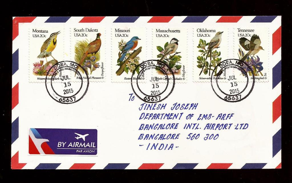
My US Statewise cover collection is growing. My good friend John Colasanti, a famous philatelist from Missouri helped me to get these covers with perfect postmarks. Thank You very much dear John for the big help from Missouri.


John sent another three very nice covers with perfect postmarks from Missouri. The old series statewise stamps are gifted by my another good friend Anna Hitchcock from Iowa, And the song birds stamps gifted by Carlos Armendariz from Texas . Thank you all for your big contribution into my cover collection.