The Sovereign Base Areas of Akrotiri and
Dhekelia (abbr. SBA; Greek: Περιοχές Κυρίαρχων Βάσεων Ακρωτηρίου και Δεκέλιας, Periochés Kyríarchon Váseon Akrotiríou ke
Dekélias; Turkish: Egemen Üs Bölgeleri
Ağrotur ve Dikelya) is a British Overseas Territory
on the island of Cyprus. The
areas, which include British military bases and installations, as well as other
land, were retained by the British under the 1960 treaty of independence,
signed by the United Kingdom, Greece, Turkey and representatives from the Greek
and Turkish Cypriot communities, which granted independence to the Crown colony of Cyprus.
The territory serves an important role
as a station for signals intelligence and
provides a vital strategic part of the United Kingdom communications gathering
and monitoring network in the Mediterranean and the Middle East. Following UK
permission, the United States was given a limited,
short-term presence on the British bases between 2013 and 2017.
Akrotiri is located in the
south of the island, near the city of Limassol (or Lemesos). Dhekelia is in the southeast, near Larnaca. Both areas include military bases, as well as
farmland and some residential land. Akrotiri is surrounded by territory
controlled by the Republic of Cyprus, but Dhekelia also borders on the United Nations
(UN) buffer zone and the area controlled by the Turkish forces. Ayia Napa lies to the east of Dhekelia. The villages of Xylotympou and Ormideia, also in the Republic of Cyprus,
are enclaves surrounded by Dhekelia. The Dhekelia Power Station,
divided by a British road into two parts, also belongs to the Republic of
Cyprus. The northern part is an enclave, like the two villages, whereas the
southern part is located by the sea, and therefore not an enclave, though it
has no territorial waters of its own. Territorial waters of 3 nautical miles
(5.556 km) are claimed, and the right according
to the laws of the UN to extend the claim of up to 12 nautical miles
(22.224 km) is reserved.
Postal services are provided by the British Forces Post Office,
with mail to Akrotiri being addressed to BFPO 57 and mail to Dhekelia and Ayios
Nikolaos being addressed to BFPO 58. Cyprus Postal Services
provides postal service for civilian homes and businesses within the Base
Areas, then using Cypriot postal codes and
"Cyprus" as country on letters from abroad.
DHEKHELIA COVERS
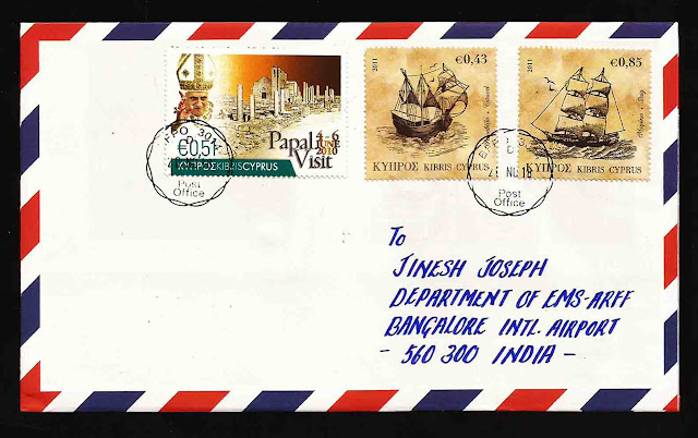
The Postmark BFPO 3014 is from Akrotiri Military Base, and BFPO 3015 is from Dhekhelia Base. The postal services run by Royal Mail with the help of British Air Force, but still my envelopes with Cyprus stamps postmarked by the postman. The covers posted on November 26, 2018 and I received on DEcember 2018
The Postmark BFPO 3014 is from Akrotiri Military Base, and BFPO 3015 is from Dhekhelia Base. The postal services run by Royal Mail with the help of British Air Force, but still my envelopes with Cyprus stamps postmarked by the postman. The covers posted on November 26, 2018 and I received on DEcember 2018


